Met Éireann Climate Statement: March 2026 wetter than normal


March 2026 was mild and sunny overall, and wet for most of the country, according to the latest climate statement from Met Éireann published today (Thursday, April 2).
There was a mobile Atlantic regime that brought winds from the south and west, with rain and showers, which were heavy at times.
The majority of stations recorded rainfall totals above their 1991-2020 long-term average (LTA) for the month.
The south and south-east was drier than average. Periods of high pressure brought dry and sunny days, according to the climate statement for March.
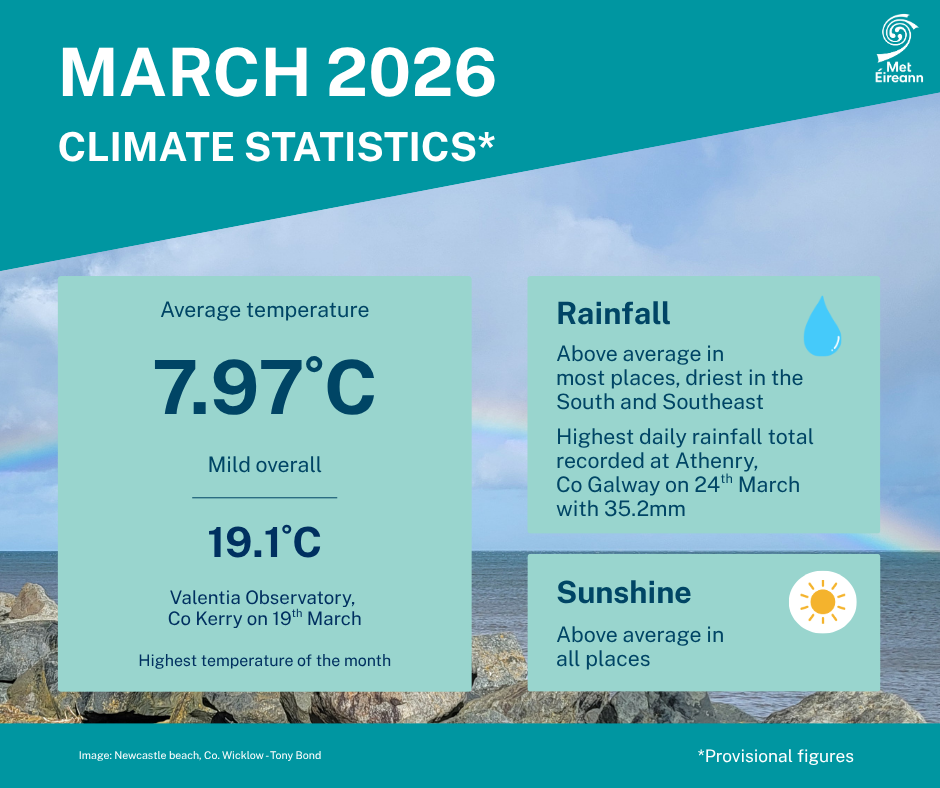
All stations recorded temperatures above their LTA with a national mean March temperature of 7.97°C.
There were also lower temperatures with wintery showers in the middle of the month, along with windier conditions particularly in the north and north-west.
The month ended with a mixture of wet and dry weather.
Key climate highlights for March 2026
- The national mean March temperature was 7.97°C, making it the 16th warmest March since 1900;
- 7.97°C is 1.51°C above the 1961-1990 LTA and 0.84°C above the 1991-2020 LTA;
- The month’s highest temperature was reported at Valentia Observatory, Co. Kerry on Thursday, March 19 with a temperature of 19.1°C (its highest max for March since 2012);
- March 2026 rainfall was wetter than normal with 108% of the 1991-2020 LTA (102.1mm) and is ranked the 36th wettest March since 1941;
- The highest daily rainfall total was 35.2mm at Athenry, Co. Galway on Tuesday, March 24.
March 2026 was mild and relatively wet overall. Low pressure to the north-west and high pressure to the south-east brought a mobile Atlantic regime for much of the month with winds mostly between southerly and westerly.
This led to periods of frontal rain or showers at times, sometimes heavy, but also periods where transient ridges of high pressure brought some dry days with pleasant spring sunshine.
The first week saw low pressure to the north-west push active weather fronts across the country from the west on Sunday, March 1 and on Thursday, March 5, with heavy rain in places.
High pressure to the south and east brought drier and sunnier conditions on other days.
It became much windier during the second week with deep low pressure systems to the north-west bringing rain or showers on most days.
Widespread heavy rain, sometimes thundery, swept across the country on Thursday, March 12 followed by a few cool days with wintry showers.
The third week began with low pressure to the north-west sending weather fronts, interspersed with showers, across the country in a westerly airflow.
High pressure built over the country during the second half of the week and brought a calm, sunny, relatively warm and dry period between Thursday March 19 and Saturday, 21.
The final 10 days of the month saw a mobile Atlantic regime returning with further periods of rain or showers, including heavy frontal rain crossing the country on Tuesday March 24, interspersed with a few mostly dry days.